


Regrid Property App
4.72.61K Reviews
App Specs
- Version
- 1.89.0
- Updated On
- License
- Free
- Downloads
- 500,000+
- Developer
- Regrid
- Categories
- Maps & Navigation
- Platform
- Android, iOS
Screenshots
 Analysis by AppCompare
I often reach for a parcel map when an ordinary street map answers the wrong question. It can show me how to get somewhere, but not where one property ends and the next begins, or how a patch of land is classified. That distinction is the reason I find Regrid Property App useful: it is built around looking up land and parcel information rather than simply planning a route.
Start with the question you need answered
Before opening any property map, I find it helps to decide whether I need a quick orientation or a lead for further research. If I just want directions to a shop, a conventional navigation app is the better fit. If I am trying to understand a parcel’s mapped outline, land use, zoning, acreage, or ownership details, Regrid has a more relevant focus. It is a free Maps & Navigation app from Regrid, with optional in-app purchases listed from $9.99 to $100.00 per item.
That focus makes it especially useful for people who regularly move between a map and property questions: real estate researchers, landowners, planners, and curious neighbors. It can also help a prospective buyer prepare more focused questions before contacting an agent or local office. I would treat what I find as a starting point for investigation, not as a substitute for confirming important details with the appropriate local source.
Why the parcel-first view is valuable
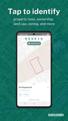
When I want to compare nearby pieces of land, parcel boundaries can make a map much more informative than a familiar street view. Regrid puts property information in a geographic context, so I can connect a record with the place it describes rather than trying to reason from an address alone. That is a practical difference, particularly around large or irregular lots where the street address does not tell the whole story.
A useful workflow is to begin with a known address, inspect the mapped parcel, and then note questions that need follow-up. For example, if a property appears to include more land than its visible frontage suggests, I would use the map to understand the shape and then verify any consequential boundary or acreage question through an authoritative channel. The map can help me ask better questions; it should not be treated as a survey or legal determination.
The app’s search options also suit different starting points. An address is handy when I am standing near a property or looking at a listing. An owner name or parcel number may be more useful when I already have a record or want to distinguish similar addresses. I would not assume every search term will be equally convenient in every situation, so it is worth trying the identifier you actually have rather than forcing an address-based search.
Where it fits beside other map tools
Compared with general-purpose navigation apps, Regrid is less about choosing a route and more about understanding land on the map. Compared with property listing apps, its parcel-focused approach is more relevant when the question is about a mapped lot rather than photos, marketing copy, or a home’s interior. Those tools can still be better for browsing homes for sale or getting turn-by-turn directions; Regrid makes most sense as a complementary research tool.
Worth Reading Before You Choose

EA SPORTS FC Mobile 26 Is a Bigger Football Game, but It Takes Time

Flipboard Shows What News Apps Must Do Beyond the Feed

Switching to Android Auto Means Rethinking Your Driving Routine

Google Calendar Makes a Crowded Week Easier to Manage

Ludo King Makes the Most of the Minutes Between Plans

Baby Panda World Brings Quick Play to Modern Phones, but Its Game Library Feels Busy
That distinction matters in a realistic everyday scenario. Imagine I am considering a home outside a dense neighborhood and want to understand what the surrounding parcels look like before arranging a visit. I can search the address, inspect the boundaries, and use the land-use or zoning information to decide what to ask next. I would then check important claims through the relevant local records or a qualified professional instead of treating a screen as final proof. The app helps me prepare, but it does not remove the need for due diligence.
Good habits for researching a parcel
I get more out of a property map when I keep the search narrow. I start with one address or parcel identifier, check that the selected outline corresponds to the place I mean, and only then explore the surrounding area. This reduces the chance of carrying a nearby parcel’s details into my notes by mistake. If I am comparing several properties, saving interesting ones and adding a short note about why each caught my attention can make later review much less confusing.
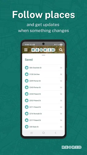
Saved properties and notes are particularly useful for a multi-step search: I can record a question such as “confirm access” or “check zoning locally” while the map is in front of me, rather than relying on memory after switching tasks. I would keep those notes factual and brief, and avoid treating a personal note as verified property information. This is a small workflow choice, but it turns casual browsing into a more organized shortlist.
One trade-off is that more data does not automatically mean more certainty. Parcel lines and classifications are valuable context, yet a mapped boundary is not the same thing as a surveyed line on the ground, and a zoning label does not guarantee that a particular plan will be allowed. For purchases, construction, disputes, or other high-stakes decisions, I would use Regrid to frame the question and then seek confirmation from the relevant authority or professional.
First Impressions: Getting Started with Regrid
So, I fired up the app, and right off the bat, it felt surprisingly intuitive. The Regrid Property App doesn’t bombard you with overwhelming options. Instead, it greets you with a clean interface, which instantly scored points in my book. Navigating through the app is like taking a stroll in a well-organized park—not a labyrinth.
Downloading it was a breeze, available on both Android and iOS, ensuring you can access it irrespective of your allegiance in the smartphone wars. Once installed, it asks for your location to provide accurate property data around you. If you're the privacy-conscious type, no worries—it allows manual location entry, too.
The Heart of Regrid: Features and Functionality
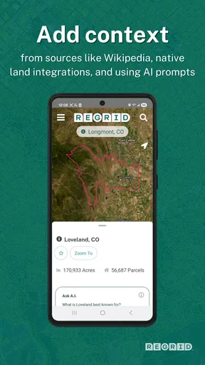
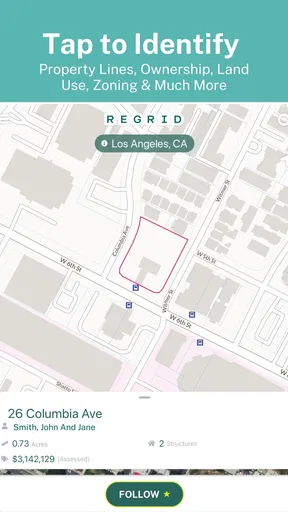
Now, let’s dive into what this app is packing. Regrid Property App is all about providing detailed property data, and boy, does it deliver. From ownership details to land use classifications, it serves up a buffet of information. For someone who loves data (guilty!), it’s like Christmas morning.
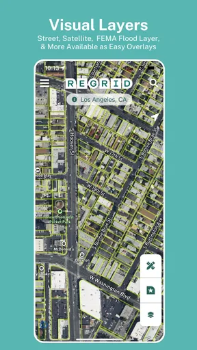
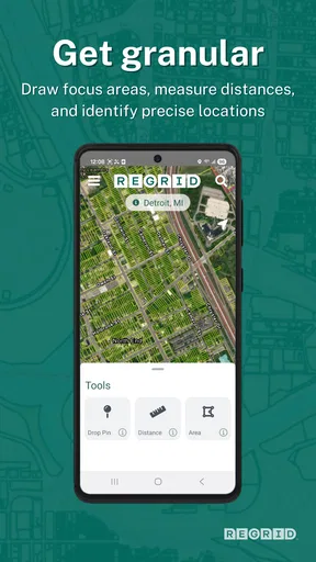
What caught my eye was the map feature. It’s not just any map; it’s a dynamic map that overlays property boundaries and details with ease. You can search by address, owner name, or even parcel number. This functionality is a godsend for anyone involved in real estate or urban planning.
The app also allows you to save properties for easy access later. Whether you're scouting for potential investments or just a curious cat, this feature ensures you don’t lose track of interesting finds. Plus, the notes feature lets you jot down thoughts or additional info, which is super handy.
User Experience: Smooth Sailing or Rough Waters?
Let’s talk user experience. The Regrid Property App runs smoothly without any major hiccups. During my time fiddling with it, I didn’t encounter any crashes or freezes, which is a win in my book. The app is responsive and quick, making the experience enjoyable rather than a test of patience.
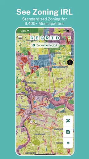
The design is straightforward yet effective. While some might crave more visual flair, I appreciate the minimalist approach. It keeps the focus on the data without unnecessary distractions. Plus, the color-coded map layers add a nice aesthetic touch, making it easy to differentiate between zones and types.
Who Should Use Regrid?
If you’re in real estate, urban planning, or even just a data enthusiast, this app is worth checking out. The wealth of information it provides is valuable for professionals and hobbyists alike. Regrid Property App serves as a powerful tool in the hands of those who know how to wield it.
However, if you’re someone who’s looking for a casual browsing experience without much data digging, this might not be your cup of tea. It’s tailored for those who have a purpose in mind, be it research or investment scouting.
Cost, upkeep, and the switch from your usual map
The basic app is free, which makes it easy to try alongside the mapping tools I already use. The optional purchases mean I would check what an upgrade includes and whether it matches my actual workflow before paying; I would not assume a paid option is necessary just because I am doing occasional lookups. The app is rated for Everyone, and its current version is 1.84.0, so it is presented as a general-audience tool rather than a specialist product that requires a particular profession.
Regrid has a 4.6 average from around 4.9 thousand ratings, with over 500 thousand installs and around 2.2 thousand written reviews. Those figures suggest that plenty of people have tried it, but they do not tell me whether its parcel coverage or detail will answer a specific local question. I would test it on a property I already know before relying on it for a larger project. It was released on March 6, 2018, and the minimum operating system listed is version 7.0.
Switching does not need to mean replacing every map app on my phone. I would keep a standard navigation app for driving and use Regrid when the task changes from “how do I get there?” to “what land am I looking at?” That split is practical: it avoids expecting a parcel tool to behave like a route planner, while letting each app handle the question it is better suited to answer.
When I would choose another approach
If I were shopping mainly for homes, I would start with a real-estate listing service, because its central purpose is browsing available properties and their presentation. If I needed a route, traffic context, or nearby everyday places, I would open a general navigation app. And if a boundary affects a purchase, fence, easement, or building plan, I would not settle the matter through any map alone; I would seek the appropriate official records or a qualified surveyor.
There is also a learning curve in knowing what to do with the information. Someone who opens the app without a parcel, address, or research question may find the map less immediately rewarding than a tool designed for casual discovery. That is not a flaw so much as a mismatch: Regrid’s value grows when I arrive with a purpose and take time to interpret what the map is showing.
Final Thoughts: Is Regrid Worth Your Time?
In a nutshell, the Regrid Property App is like a Swiss Army knife for property data enthusiasts. It’s packed with features, user-friendly, and delivers on its promises. For anyone serious about property data, it’s a valuable addition to your digital toolkit.
So, would I recommend it? Absolutely. Whether you’re a real estate mogul in the making or just someone who loves diving into data, give Regrid a whirl. Who knows, you might just find your next big project or investment gem!
My recommendation comes with a clear boundary: use it to orient your research, compare parcels, and keep track of questions, not to make a legal or financial decision on a map view alone. For a curious property owner or someone preparing for a site visit, that is a useful role. If you only need directions or listing photos, another category of app will probably serve you better. For me, Regrid earns a place beside those tools because it answers a different, more land-focused question.
Pros
- User-friendly interface enhances navigation.
- Comprehensive property data coverage.
- Real-time updates keep info current.
- Customizable search filters available.
- Offline access to saved properties.
Cons
- Limited features in the free version.
- Occasional slow loading times.
- Requires stable internet for updates.
- In-app ads can be distracting.
- Some data may be outdated.
FAQs for Regrid Property App
What is the primary function of the Regrid Property App?
The Regrid Property App is designed to provide comprehensive property data and mapping tools. It allows users to access parcel boundaries, ownership information, and geographical data for properties across the United States. This app is particularly useful for real estate professionals, developers, and anyone interested in property research.
Is Regrid Property App available for both Android and iOS devices?
Yes, the Regrid Property App is available for download on both Android and iOS platforms. Users can find it on the Google Play Store for Android devices and the Apple App Store for iOS devices. This ensures accessibility for a wide range of users, regardless of their preferred device.
Does the Regrid Property App offer offline access to property data?
The Regrid Property App primarily requires an internet connection to access the most up-to-date property data and mapping features. However, some features may be accessible offline if data is cached beforehand. For the best experience, using the app with an internet connection is recommended to ensure data accuracy and functionality.
Are there any subscription fees associated with using the Regrid Property App?
While the Regrid Property App offers a range of free features, there are also premium options available that require a subscription. These premium features typically include advanced tools and additional data access. Users can choose the plan that best fits their needs, depending on the level of detail and features required for their projects.
How accurate is the property data provided by the Regrid Property App?
The Regrid Property App sources its data from reliable, authoritative databases, ensuring a high level of accuracy. However, as with any data service, there may be occasional discrepancies. Users are encouraged to verify critical information independently, especially for legal or financial purposes, to ensure precision and reliability.


